Linked Paths is a sandbox web application for experiments in representing historical geographic movement: journeys, named routes (and route systems), and flows. The term path, (synonymous with course), refers to the spatial-temporal setting for any of these. Linked Paths displays several exemplar datasets formatted as GeoJSON-T, my proposed temporal extension to the venerable GeoJSON.
The site features and functions bear some explanation, as they’re not all immediately apparent.
Historical geographic movement data:
Journeys, Routes, and Flows
Last fall, Lex Berman, Rainer Simon and I came up with draft conceptual and logical models of historical geographic movement, which are described in some depth in blog posts here and here. Briefly, we posit three classes of movement we wish to model.
Journeys
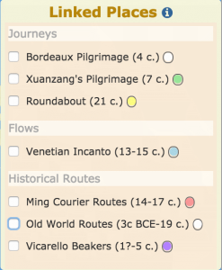
Journeys are events—individual occurrences of one or more persons moving between two or more places over some period of time. Journeys are often typed according to purpose (pilgrimage, expedition, migration, march, Grand Tour, etc.) or mode of travel (voyage, flight). Spatial data for journeys always includes two or more places (i.e. an itinerary), normally ordered temporally. The actual paths traveled between places may be known, unknown, estimated, or ignored. Similar variation in completeness holds for temporal attributes as well: we might know the year(s) or decade(s) the journey took place, dates for some or all departures and arrivals, durations of segments, or simply sequence. Linked Paths depicts two pilgrimages from the 4th and 7th centuries, and a recent 5-month journey of my own I called “Roundabout.”
Named routes and route systems (hRoutes)
Routes are the named courses of multiple journeys known to have occurred over a period of time (notably, for trade and religious pilgrimage); they are differentiated from the physical media for those journeys (roads, rivers, etc.). That is, a route may comprise segments of multiple roads and rivers. Exemplar route data in Linked Paths are for Old World Trade Routes, Ming Dynasty Courier Routes, and the pilgrimage route described on the Vicarello Beakers. Other well-known route systems include the Silk Road, the Pilgrimage Routes to Santiago de Compostela, the Incense Route, the Amber Routes.
Flows
Flows are aggregated data about journey events; that is, the movement of something at some magnitude over some period of time. The Incanto Trade flow example in Linked Paths aggregates data about the number of ships involved in 840 individual commercial voyages outward from Venice between the 13th and 15th centuries.
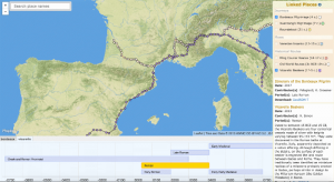
A map and data-dependent temporal visualization
Linked Paths consumes data in GeoJSON-T format and renders it on the fly to a web map and one of four kinds of temporal visualization depending on the nature of the data:
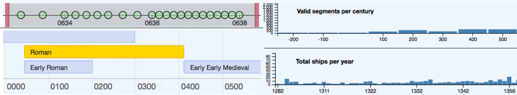
- a timeline of events (journeys)
- a timeline depicting a relevant period and its immediate context, drawn from PeriodO collections (where period is the only temporal information known)
- a histogram indicating the number of segments valid for a period (time-indexed trade routes)
- a histogram indicating magnitude of flows per period
The color for journey segments is scaled: earlier=lighter, later=darker
Linked Data
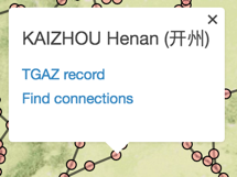
Place dialog popups include links to gazetteer APIs, including Pleiades, GeoNames, and the temporal gazetteer (TGAZ) of Harvard’s China Historical GIS.
Period timelines for Courier, Vicarello, and Bordeaux datasets are drawn dynamically from the PeriodO API, rendering the relevant period and adjacent neighbors from a collection.
Search
Query a union index of selected fields in all Place records from the 7 individual project gazetteers. Results are grouped by dataset, and leverage name variant data within Place records. For example, Dubrovnik and Ragusa are known to refer to the same place.
The “Find connections” link in place popups (Fig. 4) queries identifies segments associated with a given place from all 7 datasets.
GeoJSON-T
The GeoJSON-T format is a work-in-progress. Code and preliminary documentation is available at its GitHub repository.
Briefly, GeoJSON-T:
- Permits adding an optional “when” object to Features in one of two locations
- as a sibling to “geometry” in a Feature
- as a sibling to “coordinates” in each member of a GeometryCollection
- Leverages GeometryCollections for changing geometries over time (similarly to the HistoGraph project) and permits “properties” in GeometryCollection members
- Will be processed by existing GeoJSON-compatible software, simply ignoring “when” objects and processing geometry and properties found in the standard places