Linked Places Format (LPF)
Screenshots

Organization
University of Pittsburgh World History Center and broadly, the Pelagios Network
Roles
Principal Author; Developer; Data Modeling Lead
Technologies
JSON-LD; GeoJSON; RDF; Linked Data; Python; data modeling; temporal GIS concepts; gazetteer interoperability frameworks
Description
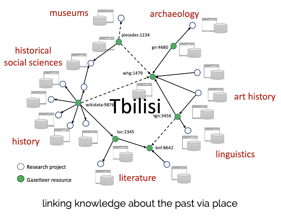
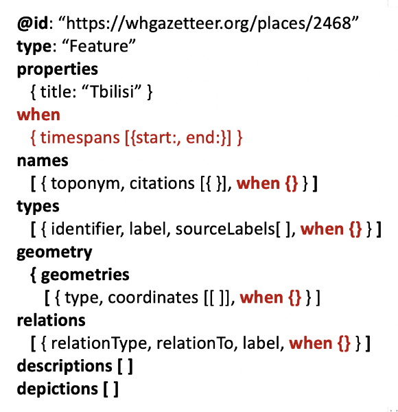
Linked Places Format (LPF) is a lightweight, extensible data format for representing historical place information with temporal depth and semantic clarity. It offers a pragmatic solution to a longstanding challenge in geographic information science: how to incorporate time—often complex, uncertain, or culturally variable—into spatial data models. It also answers requirements of gazetteer systems for standard ways of including multiple values for temporally scoped place attributes.
LPF grew out of two earlier efforts. The first was TopoTime, developed with Elijah Meeks at Stanford Libraries, which drafted a formal scheme for expressing uncertain or complex historical timespans. The second was GeoJSON-T, an experimental extension to GeoJSON that introduced standardized "when" elements for temporal scoping. GeoJSON-T attracted early interest but remained a prototype. When the World Historical Gazetteer (WHG) launched, GeoJSON-T became the conceptual foundation for LPF, which extended the format further by supporting multiple temporally scoped names, geometries, types, relations, and citations in a single place record. LPF is thus the culmination of a multiyear line of research into bringing temporal structures into web-native geographic data models.
LPF is designed around JSON-LD, making every instance valid RDF and enabling interoperability with Linked Data ecosystems. At the same time, it remains valid GeoJSON, ensuring immediate compatibility with web mapping tools. This dual nature supports a key goal: enabling researchers to integrate place attestations from many sources without imposing a single “canonical” model. As emphasized in the chapter Place, Period, and Setting for Linked Data Gazetteers historical gazetteers must represent an interplay of spatial and temporal characteristics, described therein as settings. LPF provides an applied, implementation-friendly mechanism for representing those settings in practical workflows.
Originally developed for contributions to partner projects in the Pelagios Network—including the World Historical Gazetteer, Recogito, and PeriodO—LPF has since become a general-purpose format for publishing spatio-temporal place data. Its aim is not to define a single universal gazetteer schema but to offer a minimal, flexible structure that enables linking between diverse gazetteers, helping users search across them, disambiguate places, and annotate data with stable URIs.
LPF represents one of my most sustained contributions to digital humanities and geographic information science: a workable, community-adopted approach for representing place + time together in a machine-readable, web-native format suitable for historical research at scale.